The Eagle Migration
Migration Route outline
General
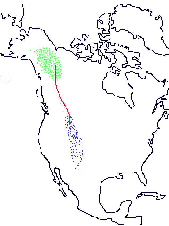
Each spring large numbers of Golden Eagles fly from their wintering grounds (the mountain states of western U.S.A. to as far south as northern Mexico) to breeding grounds in Alaska and Yukon. They return south in the fall.
The population of Golden Eagles is widely scattered in their wintering and breeding grounds and therefore almost impossible to study.
But along the migration route(s), they pass by in relatively narrow streams and large numbers can be observed.
Our main study efforts have been concentrated at observation sites in the front ranges of the Rocky Mountains of Alberta where one large stream of Golden Eagles passes twice each year.
Another stream uses geological features along the Rocky Mountain Trench in British Columbia, and sporadic counts have been conducted there near Cranbook, BC.
When do they migrate?
The first Golden Eagles go north in late February. The peak migration period lasts from mid-March to the first week of April. The spring migration is over by mid-May.
In the fall some Golden Eagles are seen to return south in late August. The peak migration lasts from mid September until the beginning of November. Dwindling numbers are seen until early December.
When can they be seen?
Migrating Golden Eagles roost on the ridges during the nights and some start moving soon after dawn. We have found over many years that, in good migrating weather, the movement tends to build up during the morning and reach a maximum in mid-afternoon. Movement stops as it is getting dark and we often see the birds settling on the peaks.
We cannot predict when a big movement will take place. Very often, perfect migrating conditions at our observation sites produce few sightings because the flow may be blocked by poor conditions elsewhere. At other times our own bad weather is the cause.
Some years ago eagle enthusiasts from Japan came to see the unique migration. Every day the mountains were shrouded by cloud but about noon on their last day the wind shifted, the clouds lifted and that afternoon over 500 Golden Eagles flowed through. It was almost as if a dam had burst.
For weather comfort, together with plenty of eagles, we have found early October to be the best time of year – beautiful warm days and beautiful fall colours. However come prepared for sudden changes.
Why the front ranges?
A little geology helps to answer this. The eastern Rockies in Alberta were formed from layers of hard and soft sedimentary rock which were folded and thrust up by great pressure from the south-west. Along the front (eastern) ranges the layers are turned up into an almost vertical orientation. Weathering over a great length of time has left the hard layers (mostly limestone and dolomite) standing as almost straight south-east to north-west trending ridges. These ridges parallel the eagle’s desired route between wintering and breeding grounds. They also happen to trend at right angles to the prevailing wind and these conditions, rising up the western slopes of the ridges, generate up-drafts which eagles use to maintain height with as little flapping as possible. When wind conditions are right the eagles sail by at over 100 km/hour with hardly any effort. On calm days they use thermals forming over peaks and soar up in them to great heights which allow them to go on to the next thermal in a shallow diving glide. When a number of eagles are soaring together, the group is called a kettle of eagles. Kettles are a magnificent sight and as many as sixty eagles have been seen gaining height in one kettle over the Fisher Range near the Hay Meadow, Mount Lorette site.
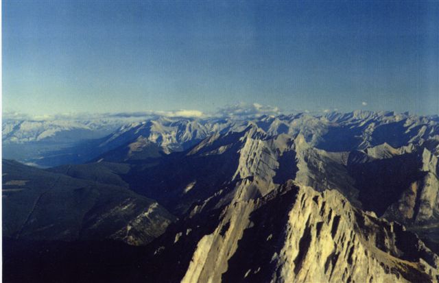
Southwest Northeast
Alaska straight ahead – We call it the eagle highway. Fisher Range
CR George Halmazna.
Why the Rocky Mountain Trench in British Columbia?
This is a topographic feature of such continuity and length that it is very evident from space. It is a broad and deep valley stretching from northwestern Montana through the length of B.C. and into the Yukon. The mountains rimming this valley are thought to provide a near perfect route between the Golden Eagle wintering grounds in the western U.S.A and their breeding grounds in northwest Canada and Alaska.

Rocky Mountain Trench
Observation Sites in Alberta & British Columbia
You would think that with 700 km of front ranges in Alberta and another 400 km in northeast British Colombia there should be many excellent sites for Golden Eagle observation. However, good observation sites are of little use if they are too far from the people who observe them or too hard for those people and interested visitors to reach. As you can see the front ranges of the Rockies can be quite a barrier. In fact they are pierced by only a handful of passes suitable for highways. Smaller, more remote passes exist but the gravel roads or trails using them tend to be of poor quality. Weather is also a problem especially during spring when the smaller passes remain snowbound until the migration is over.
The Perfect Site – (Of course it doesn’t exist; but if it did, it would have the following features):
- Close viewing of migrating Golden Eagles and other raptors.
- Situated on a topographic feature along which most of the raptors are funnelled.
- No close trees or other objects to obstruct clear view in all directions.
- Experienced observers who are able to identify and classify close & distant raptors.
- Enough experienced observers to allow complete coverage of the peak portions of every migration.
- Trained helpers who aid in the search for passing raptors etc.
- Good road access to a nearby parking spot.
- Easy walk from parking spot to the site.
- Secure storage for optical and other equipment.
- Some form of shelter during squalls etc.
- Reasonably close accommodation where visitors can stay.
- Situated within reach of a large centre where interested people live.
The main ingredients are many observable raptors, plenty of good people and easy access.
RMERF currently has just one main observation site in Kananaskis Country, 90 km west of Calgary. Secondary locations are near the east end of the Crowsnest Pass in south-west Alberta.